
Table of Contents
Umm Yifenah Island is a natural, mostly undeveloped island off the coast of Abu Dhabi, sitting between Al Reem Island and Saadiyat Island. A six lane bridge reached it in February 2023, and a much bigger road project is now under way.
The island has no visitor centre, no public beach facilities and no ticketed attractions yet. What it does have is open shoreline, mangrove fringed water and a front row seat to the capital’s next big road link.
That mix makes it an unusual topic. Most Abu Dhabi islands are either built up or closed off.
This one sits in between. It is crossed by a major highway, yet it remains quiet, natural land.
If you are curious about it, here is what is actually there, how to reach the area and what is coming next.
Where Is Umm Yifenah Island?
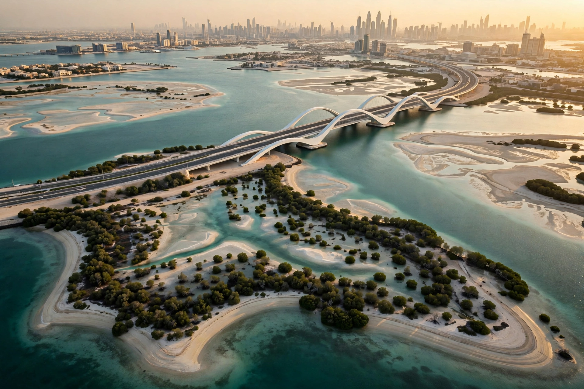
Umm Yifenah Island sits in the channel between Al Reem Island and Saadiyat Island, just off Abu Dhabi’s main island. The Umm Yifeenah Bridge links it to Al Reem Island on one side and to Sheikh Zayed bin Sultan Street on the other. That position puts it close to the city centre, even though it still feels removed from it.
One thing to clear up first is the spelling. Official releases from the Abu Dhabi Media Office spell it “Umm Yifeenah”. Many blogs and search results use “Umm Yifenah”.
Both spellings point to the same island. This article uses the common search spelling in the title and headings, and the official spelling when quoting official sources.
The island is part of Abu Dhabi’s mid island chain. Saadiyat Island lies to the north east. Jubail Island sits nearby.
Al Reem Island, with its towers and waterfront promenade, is the closest built up neighbour. The water around the island is shallow in places, with mangrove edges and sandy shoreline.
The Bridge That Put the Island on the Map
Before 2023, the island was hard to reach and rarely talked about. That changed on 9 February 2023, when Sheikh Khaled bin Mohamed bin Zayed Al Nahyan inaugurated the Umm Yifeenah Bridge. The bridge is an 11 kilometre superhighway that creates a rapid connection between Al Reem Island, the island itself and Sheikh Zayed bin Sultan Street.
The numbers behind the bridge are worth knowing. It has six lanes and was built by Aldar in partnership with the Department of Municipalities and Transport.
It can carry 6,000 journeys per hour in each direction, or 12,000 per hour in total. Walking and cycling paths run alongside the road, and bike rental facilities were included in the project.
The bridge did more than shorten a drive. It turned a quiet stretch of water into a corridor.
Traffic that once had to loop around the city could now cross straight through the mid islands. For residents of Al Reem Island, it opened a faster way toward Sheikh Zayed bin Sultan Street and the roads beyond.
What the Island Looks Like Today
Drive across the bridge and you will see the island rather than visit it. There are no hotels, cafes, shops or marked viewpoints on the island. It remains open, natural land with sandy shores, shallow lagoons and mangrove edges. That is the honest picture, and it is also what makes the place interesting.
The shoreline is the main feature. Soft sand meets clear, shallow water along much of the coast.
Mangroves fringe the quieter edges, and the wider area is known for wading birds. At sunrise and sunset, the light across the water and the city skyline makes the crossing itself worth the trip.
There are no published visitor facilities on the island. No entry fee applies, because there is no gate, no ticket office and no attraction to enter.
No public beach access points, toilets or shaded picnic areas are listed for it. Anyone planning a beach day should treat the island as a place to look at and drive through, not as a destination with services.
That may change. The road projects described below will bring far more traffic and attention to the island. For now, though, the right expectation is a scenic crossing and a glimpse of natural coastline, not a full day out.
The Mid-Island Parkway and What Comes Next
The Umm Yifeenah Bridge was only the first phase of a larger plan. The Mid-Island Parkway is the road network that will eventually link Saadiyat Island, the island, Al Raha Beach and Khalifa City. It is one of the biggest transport projects in the capital, and it puts the island at the centre of the map.
The Department of Municipalities and Transport announced the latest update on 1 October 2026. Phase One of the parkway, worth AED 2.85 billion, is scheduled for completion in 2027. It is an eight lane dual carriageway that runs from the northern Saadiyat interchange on the E12 highway, down to the southern end of Saadiyat Island, and across to the Umm Yifeenah Island Central Interchange.
| Phase | What it covers | Status |
|---|---|---|
| Phase One | Eight lane dual carriageway from Saadiyat’s northern E12 interchange to the Umm Yifeenah Island Central Interchange, AED 2.85 billion | Due for completion in 2027 |
| Phase Two | 14.5 km extension through Bilrimaid and Samaliyah Islands to Sas Al Nakhl, Al Raha Beach and Khalifa City | Announced, no completion date published |
| Full network | Saadiyat Island linked to Zayed City in under 15 minutes | Planned |
The journey time figures are the part drivers will notice most. Once Phase One opens, the trip from Saadiyat Island toward Al Reem Island and Abu Dhabi’s main island is expected to drop from around 25 minutes to about 10 minutes. Phase Two is expected to bring mid island journeys down to around seven minutes.
An earlier release from 2023 put the full parkway network at completion by 2028. The October 2026 update confirms Phase One for 2027 and gives no date for Phase Two. Readers should treat the 2027 date as the firm one and the rest as planned work.
Phase One also adds four kilometres of walking and cycling tracks. These extend an existing Saadiyat path into a continuous 12 kilometre active travel corridor that reaches the island. Phase Two is planned to include walking and cycling tracks, marine bridges, elevated flyovers and an underwater road tunnel.
Marsa Al Saadiyat, the New Neighbour Next Door
The other big change sits just across the water. Marsa Al Saadiyat is Aldar’s AED 100 billion waterfront development on Saadiyat Island. It is the final phase of the Saadiyat Island masterplan, renamed from the Saadiyat Marina District. The project covers 6.4 million square metres and is planned to house close to 60,000 residents.
The scale is large by any measure. Plans include Abu Dhabi’s largest marina, with capacity for up to 350 berths.
The development is planned to have 8 kilometres of coastline and 5.6 kilometres of beach. Site enabling and infrastructure work began in the third quarter of 2026, and sales of the first homes are planned for the second half of 2026.
What matters for this island is the connection. Marsa Al Saadiyat is planned to link with Umm Yifenah Island and Al Reem Island through a new network of roads and tunnels.
An underground Etihad Rail high speed station is also planned for the development, which would connect it with the other emirates. A new bridge will link the district to another island Aldar is developing off Saadiyat’s coast.
Taken together, the parkway and Marsa Al Saadiyat mean the island will not stay quiet forever. It sits between two of the capital’s biggest projects. The natural shoreline is the reason to pay attention now, before the construction changes the area.
Can You Visit Umm Yifenah Island?
Yes, you can cross it, but you cannot really visit it in the usual sense. The bridge is a public highway, so anyone can drive across it. The walking and cycling paths give another way to experience the crossing. The views across the water toward the Al Reem Island skyline are the main reward.
What you cannot do yet is plan a day on the island itself. There are no published walking trails, beach access points, cafes or facilities.
There is no visitor information point. The island is natural land crossed by a highway, and it should be treated that way.
A few practical points help if you do go:
- Drive the bridge route in the early morning or late afternoon, when the light is best and the heat is lower.
- Use the walking and cycling paths rather than stopping on the highway. The bridge is a fast road.
- Bring water and sun protection. There are no shops on the island.
- Take all rubbish away with you. The shoreline and mangroves are sensitive, and there are no bins or cleaning services on the island.
- Combine the crossing with a stop on Saadiyat Island or Al Reem Island, where facilities do exist.
What to Do Nearby Instead
The area around the island has plenty to offer. If you want the beach, nature or skyline views that the island promises, these nearby places deliver them today.
Saadiyat Beach. A short drive from the bridge, Saadiyat’s public beach has soft white sand and clear water. The island’s cultural district sits nearby, with the Louvre Abu Dhabi, the Zayed National Museum and teamLab Phenomena.
Jubail Mangrove Park. On Jubail Island, close to the bridge route, the mangrove park has a boardwalk through the trees and kayaking through the channels. It is the easiest way to experience the same mangrove landscape that fringes the island.
Al Reem Island waterfront. The promenade and cafes on Al Reem Island give you the skyline and marina views without leaving the built up city. It is also the closest place to stop for food after crossing the bridge.
Saadiyat Island cultural district. The Louvre Abu Dhabi and the newer museums sit within a short drive. Pairing a morning at the museums with an afternoon drive across the bridge makes a simple half day plan.
When to Visit the Area
The best months are November to March, when Abu Dhabi is cooler and outdoor time is comfortable. Mornings are the best part of the day for the bridge crossing, with softer light and lighter traffic. Summer brings high heat and humidity, so any walking or cycling should happen early or not at all.
There is no ticket or opening time to work around, since the bridge is a public road and the island has no gated attraction. That makes the area easy to fit into a wider day around Saadiyat Island or Al Reem Island.
Questions People Ask
Where exactly is Umm Yifenah Island?
It sits between Al Reem Island and Saadiyat Island, off the coast of Abu Dhabi. The Umm Yifeenah Bridge connects it to Al Reem Island and Sheikh Zayed bin Sultan Street.
Can you drive to Umm Yifenah Island?
Yes. The bridge is a public six lane highway, and the drive across it is open to all traffic. The island itself has no visitor facilities, so the crossing is the experience.
Is there a beach you can swim at?
No public beach with facilities is listed for the island. Saadiyat Beach, a short drive away, is the nearest proper beach with services.
When will the new Mid-Island Parkway open?
Phase One, linking Saadiyat Island to the Umm Yifeenah Island Central Interchange, is scheduled for completion in 2027. No completion date has been published for Phase Two.
What is Marsa Al Saadiyat?
It is Aldar’s AED 100 billion final phase of the Saadiyat Island masterplan. It will link to the island and Al Reem Island by road and tunnel, and it is planned to include the capital’s largest marina.
Is the island worth visiting now?
If you enjoy quiet coastline and big infrastructure, yes, as a drive and a viewpoint. If you want a beach day with facilities, head to Saadiyat Island instead and cross the bridge on the way.
Umm Yifenah Island is easy to miss and hard to forget once you know it is there. A six lane bridge already crosses it. A AED 2.85 billion parkway will reach it in 2027.
A AED 100 billion neighbourhood is rising next door. For now it stays quiet, natural and open, and that is the best time to see it.
